Climate change drives food, water, and sanitation insecurity — among the biggest threats to human survival and wellbeing.1 In 2019, 2 billion persons experienced hunger or irregular food access,2 while 2 billion persons lacked access to safely managed drinking water and 3.6 billion persons had insufficient access to basic sanitation services such as toilets and latrines.3 Adolescents’ experiences of, and solutions to, water, food, and sanitation insecurity are understudied—particularly at the nexus of climate change.4 This is problematic because very young adolescents aged 10-14, who comprise half of the 1.2 billion adolescent population—and 8% of the world’s total population— are under-represented in climate research.5 This is particularly true in Africa, where most of the global growth of the very young adolescent population is anticipated to rise 34% between 2016 and 2030, from 143 million to 193 million.5
Kenya is a salient context to develop a participatory research methodology for examining climate change, and impacts on water, food, and sanitation insecurity—also referred to as resource scarcities—among youth. Youth is the fastest growing group in Kenya6: young people under 15 years comprise 39% of the population.7 Resource scarcities are an urgent problem in Kenya, where 36% of persons live below the international poverty line of $1.90 per day.8 Under two-thirds (62%) of Kenya’s ~53 million population use at least basic water sources, and a third (33%) have basic sanitation services.3 Food insecurity is widespread9,10—evidenced in stunting from malnutrition among 29% of children in rural areas and 20% in cities8—and is amplified by climate change.11 Food insecurity has also been exacerbated by COVID-19, particularly in urban informal settlements in Nairobi and Kisumu12 and among refugees.13 Kenya is experiencing increasingly irregular rainfall and a growing number of extreme weather events (EWE), including floods and droughts.14 EWE will worsen in future decades,15 impacting the poor and vulnerable in particular.16 Despite the growing youth population, widespread resource scarcities, and climate-change impacts in Kenya, key knowledge gaps remain regarding climate change-related experiences and priorities among very young adolescents.
Participatory mapping is a collaborative process of creating maps to highlight the relationships between local communities, places, and experiences, with the ultimate goal of bringing about social change.17 This approach involves setting goals, creating and contextualizing maps, and problem-solving to effect change within the community.17 Participatory mapping is an increasingly popular tool for engaging communities, as it encourages the sharing of lived experiences among community members who may hold common objectives.18 The process holds the potential to promote relationship-building and dialogue.19 Participatory mapping approaches have been used to explore the social ecologies of HIV risk among youth in Kenya,20 rank food justice concerns in informal settlements in Nairobi,21 and examine the links between toilet infrastructure, gender, and health in Mathare’s informal settlements.22
To this end, participatory mapping is a relevant approach to enhance understanding of very young adolescents’ lived experiences, coping, priorities, and recommendation regarding climate change. The purpose of this Report is to detail the development of a multi-media participatory mapping methodology with very young adolescents in Kenya focused on identifying experiences of, and recommendations to address, climate change and resource scarcity.
CASE DESCRIPTION
This methodology was co-developed with Kenyan youth and community-based organizations for initial implementation in Kenya. We designed a multi-site participatory mapping tool to identify and address the interconnections between social, health, and environmental well-being with very young adolescents (aged 10-14). We developed this methodology in a way that it could be implemented in six locations to produce evidence and case studies across diverse ecological contexts affected by resource scarcity23: 1) informal settlements in Nairobi; 2) rural and peri-urban areas outside of Kisumu on Lake Victoria, Africa’s largest lake; 3) nomadic and pastoralist communities in Isiolo; 4) Kalobeyei Refugee Settlement; 5) flower farm worker and internally displaced families on Lake Naivasha; and 6) small scale coastal farming families in Kilifi. This approach to participatory mapping was also developed using methods to generate youth priorities and recommendations to address climate change and resource scarcity through active participation. We looked at various examples of participatory mapping from the literature and sought to draw from, combine, and build on existing approaches.
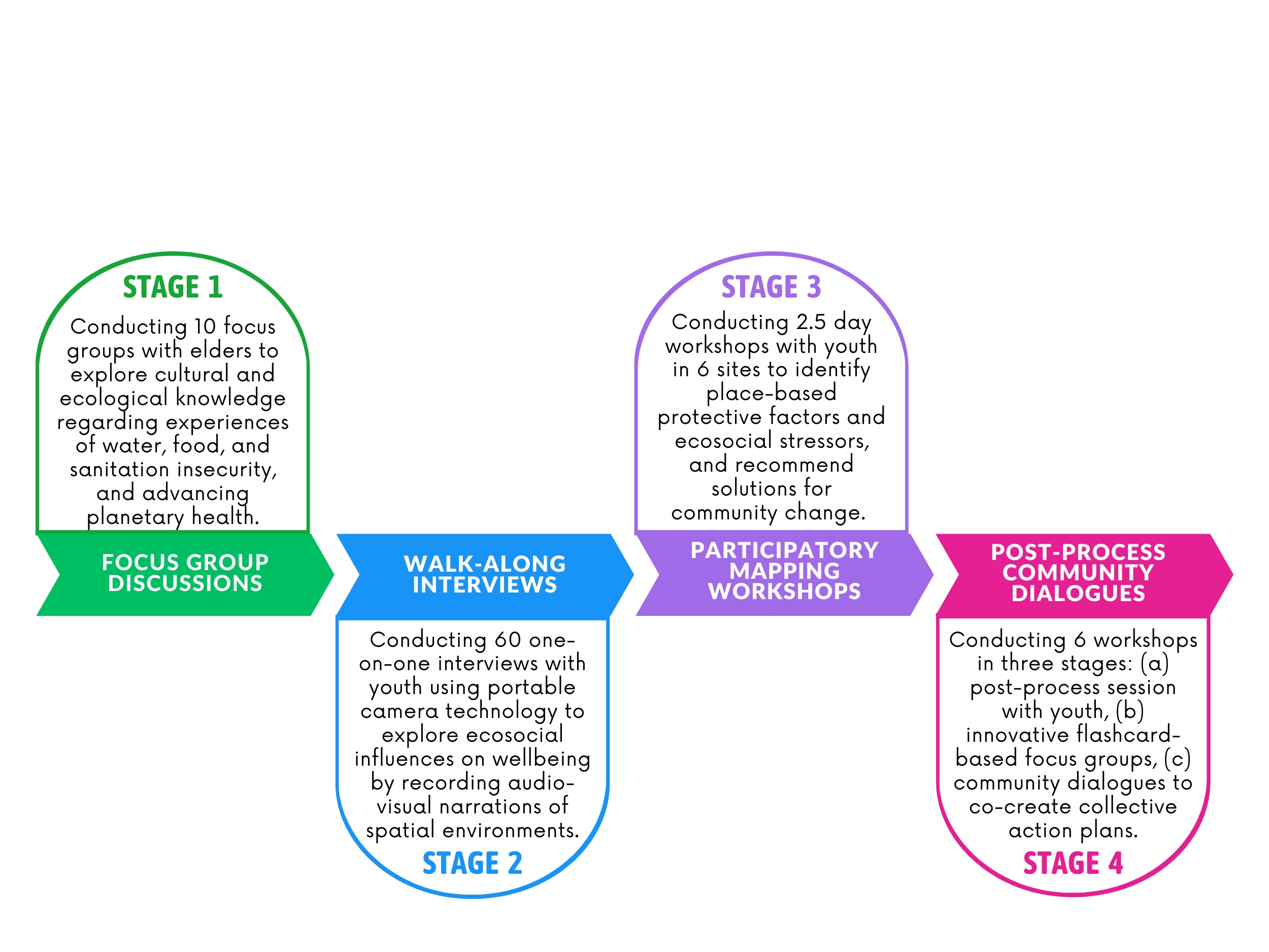
This methodology includes several phases that build on one another, as summarized in Figure 1: Phase 1) a qualitative formative phase with walk-along interviews with very young adolescents (n=10 per site) and focus groups with elders (two focus groups per site); Phase 2) developing and implementing multi-media participatory mapping (detailed in this Report) (2 workshops per site, one with adolescent girls and one with adolescent boys); Phase 3) post-participatory mapping workshops, one with adolescents and one with adults per site, and one intergenerational community dialogue per site.

Our methodology employs participatory mapping approaches to identify location-specific issues with a focus on better understanding water, food, and sanitation insecurity and their impact on youth wellbeing17 in these six sites, as well as generating youth priorities and recommendations. We present below two methodological innovations we used in this study: strengths-based approaches and multi-media approaches.
First, we intentionally prioritized a strengths-based perspective to participatory mapping to identify knowledge, resilience, and collective resources among youth.24 A focus on mapping problems, which is a common focus in participatory mapping methods,25 could unintentionally be experienced as disempowering. Alternatively, strengths-based approaches hold the potential to identify mechanisms underpinning protective factors, such as social support sources (e.g., family, peers, neighbours) and dimensions (e.g., emotional, instrumental, appraisal, and informational support26), as well as multi-level approaches to resilience (e.g., intrapersonal [e.g., coping style], interpersonal [e.g., social cohesion], community [e.g., collective efficacy], structural [e.g., advocacy]27).
For instance, our strengths-based approach to participatory mapping methods emphasize youth’s intrapersonal processes of critical hope—aspirations and belief in the potential of social change in the context of injustice28—through integrating mapping and multi-media techniques (song, dance). This approach potentially facilitates youth expressions of joy and dreams for the future to inform recommendations to improve challenging and stressful contexts of resource scarcity. This shifts the focus from a deficit-based approach of what youth struggle with and want to avoid, to a strengths-based approach focused on the changes that youth want to create and envision. This approach builds on a 2013 South African study that empowered adolescents living with HIV to envision and visually create ‘dream clinics,’ in which they mapped their visions for health and social services inside and around the clinics.29 This strengths-based approach can also be understood as a form of ‘affirmative critique’.30 This lens seeks to affirm something that exists in what is being assessed, rather than focusing on what could be denounced or avoided.30
Second, we designed multi-media approaches to participatory mapping to address the varying levels of literacy and access to technology and internet between and within the six initial target locations for methodological implementation. Multi-media approaches that integrate various art forms also align with youth-friendly approaches that allow for creative self-expression. The activities we detail below present a flexible methodology that may be applied irrespective of the written/reading language proficiency and access to digital infrastructure. The methods include various creative modes of self-expression, such as drawing, collage, writing, video, photography, dance, and music. These various methods engage different learning styles and draw on cultural strengths, including local languages, teachings and traditions. While common approaches to participatory mapping employ various techniques, imagery,31 drawing,32 and GIS technologies,21 some forms of multi-media (e.g., music and dance) are less well characterized. These activities span over 10 sessions and the materials needed for each can be found in Online Supplementary Document, Table S1.
METHODS
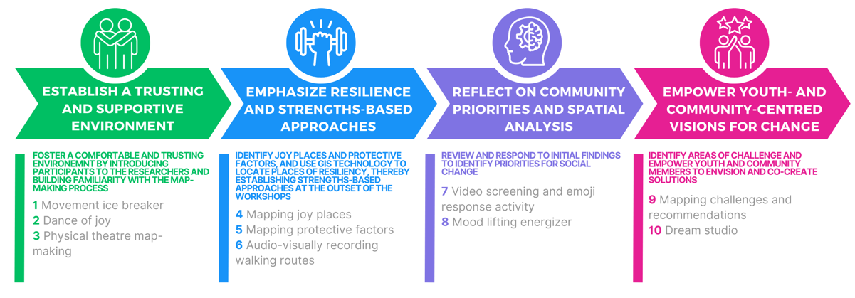
Figure 2 presents the four overarching goals that guide the session activities for these multi-media participatory mapping workshops: 1) establish a trusting and supportive environment; 2) emphasize resilience and strengths-based approaches; 3) reflect on community priorities and spatial analysis; and 4) empower youth- and community-centred visions for change.

Aligned with sex and gender-based analyses, each participatory mapping workshop is stratified by gender and includes 10 participants. Half of the participants in each workshop are youth who have participated in Phase 1 walk-along interviews, while the remainder are new youth. This provides walk-along participants the opportunity to reflect on the experiences that they shared and allows the researcher to triangulate across data sources, while simultaneously creating space for new perspectives to emerge.
Goal 1: Establish a trusting and supportive environment
The first three sessions focus on creating a trusting and supportive environment for reflection and sharing experiences. While facilitators should make sure that participants feel comfortable and supported throughout the workshop, these three sessions are critical in setting a foundation for this, and are described in Table 1.
Goal 2: Emphasize resilience and strengths-based approaches
The subsequent three sessions, as described in Table 2, include methods to identify joy places and protective factors linked with such places in the community. These sessions highlight resiliency and are at the core of our philosophy towards participatory mapping activities.
Goal 3: Reflect on community priorities and spatial analysis
There are two sessions whereby youth are engaged in reviewing, validating and building on initial findings from walk-along interviews, which are described in Table 3. This is done using embodied approaches, such as emoji stickers to share non-verbal, emotional responses; and post-response reflexive discussions. This provides the opportunity for walk-along participants to reflect on the experiences that were shared and engage with the perspectives of other youth in their community. This also allows for youth to prioritize the places in their community where they would most like to enact change.
Goal 4: Empowering youth- and community-centred visions for change
The final two sessions aim to achieve Goal 4’s focus on youth identifying priorities and recommendations for addressing the water, food, and sanitation insecurity challenges detailed in previous participatory mapping workshop sessions above, and are described in Table 4.
CONCLUSIONS
The strengths-based multi-media participatory mapping approach detailed in this Report was co-developed with youth and community-based organizations in six climate-affected regions in Kenya. This methodology offers a flexible approach that has the potential to enhance youth’s understanding of climate change and resource scarcity impacts. It also aims to uncover protective factors among young individuals, leveraging existing resources and adaptive coping strategies.24 This methodological approach addresses calls to meaninfully engage climate-affected adolescents in climate change research to ensure solutions for climate change are tailored for their needs and priorities.4
We provided guidelines and descriptions of the methodological innovations we applied to traditional participatory mapping approaches with our goal to enhance youth engagement and age- and contextual- relevance. Expanding on traditional participatory mapping techniques, our approach detailed in this Report integrates multi-media and art-based elements, including emojis, videos, photos, dances, and songs. For instance, emojis provide youth the opportunity to express emotions using youth-friendly social media imagery.36 These creative avenues provide unique opportunities to engage youth, promote self-expression, foster dialogue, and build relationships.
By prioritizing positive emotions such as joy and dreams and adopting a place-based perspective, this approach holds promise for advancing climate-resilience solutions that are both strengths-focused24 and driven by youth. Researchers and community-based organizers working on youth, climate issues, and resource scarcity may find this multi-media participatory mapping method described in the Report an engaging and adaptable method for use with diverse regions, contexts, and populations.
Ultimately, this Report presents methodological innovations for participatory mapping that can serve as a valuable resource for youth-led initiatives to address climate and health concerns. However, further research is needed to explore implementation considerations and findings from this method in order to assess its usefulness and adaptability in different contexts. Creative, engaging, and youth-friendly approaches to generating climate-related solutions continue to be of critical importance, particularly with youth in low-and middle-income climate-affected regions whose priorities and recommendations for climate-resilience and solutions are overlooked.4
Ethics statement
The study received ethics approval from two bodies: (1) University of Toronto, #27312; (2) AMREF-ERSC, #ESRC P1052-2021.
Funding
This research was funded by a Social Sciences and Humanities Research Council of Canada (SSHRC) Partnership Development Grant and the New Frontiers in Research Fund (NFRF). CHL is also supported by funding from the Canada Research Chairs Program and Canada Foundation for Innovation (CFI).
Authorship contributions
Carmen H. Logie: Substantially contributed to the conception and design of the work as Principal Investigator; acquisition, analysis, and interpretation of data; critically reviewed the manuscript for important intellectual content; provided final approval of the version to be published; agreed to be accountable for all aspects of the work, ensuring accuracy and integrity. Sarah Van Borek: Made substantial contributions to writing the manuscript and project management; critically reviewed the manuscript for important intellectual content; provided final approval of the version to be published; agreed to be accountable for all aspects of the work, ensuring accuracy and integrity. Anoushka Lad: Made substantial contributions to writing the manuscript and project management; critically reviewed the manuscript for important intellectual content; provided final approval of the version to be published; agreed to be accountable for all aspects of the work, ensuring accuracy and integrity. Lesley Gittings: Played a significant role in project conceptualization and execution; critically reviewed the manuscript for important intellectual content; provided final approval of the version to be published; agreed to be accountable for all aspects of the work, ensuring accuracy and integrity. Julia Kagunda, Humphres Evelia, Clara Gachoki, Kevin Oyugi, Mercy Chege, Beldine Omondi, Maryline Okuto, Lina Taing: Contributed to field work involving data collection; critically reviewed the manuscript for important intellectual content; provided final approval of the version to be published; agreed to be accountable for all aspects of the work, ensuring accuracy and integrity.
Disclosure of interest
The authors completed the ICMJE Disclosure of Interest Form (available upon request from the corresponding author) and disclose no relevant interests.
Correspondence to:
Carmen H. Logie
Factor-Inwentash University of Toronto
Factor-Inwentash Faculty of Social Work, 246 Bloor St W, Toronto, ON M5S 1V4
Canada
[email protected]